Upside-Down Siberia: the "cartographic Mona Lisa" at the exposition "Geography Lessons"
One of the most unusual exhibits at the exposition "Geography Lessons" at the National Centre RUSSIA is Semyon Remezov’s "upside-down" map. This is the famous "Great Drawing of Siberia", created at the end of the 17th century. It is often called the "cartographic Mona Lisa" — for its scale, its mystery, and the many layers of meaning it contains, from geography to the worldview of its era.
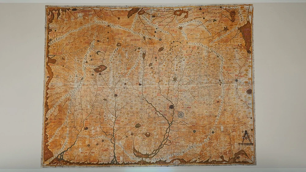
"The Great Drawing of Siberia" was created by Semyon Remezov in 1696–1698 on the orders of the Siberian Prikaz (Siberian Chancellery). Russia was rapidly expanding eastwards, but in Moscow there was only a vague understanding of what lay behind the word "Siberia" in official documents: which rivers, which cities, which peoples. The map was sent to Moscow and, according to contemporaries, made a strong impression on Peter the Great. It hung in his chambers, and the ruler used it to "examine" boyars and courtiers on their knowledge of Siberian lands.
For the exposition "Geography Lessons", the exhibit was provided by the Russian Geographical Society. The canvas is striking in scale: the map is comparable in size to the wall of a flat in a panel-built Khrushchev-era apartment. But what surprises even more is its unfamiliar view of the world: on this map, south is at the top and north is at the bottom. For a modern viewer accustomed to the "standard" orientation, this drawing looks unusual. But for the late 17th century, this approach was natural. People oriented themselves by the sun and the stars, and at midday the sun "stood" in the south — above. Remezov transferred this logic to the map: up is south, down is north, along with the reversal of west and east.
Another important detail is the distinctive script used for the inscriptions. Semyon Remezov was not only an engineer and geographer, but also an icon painter. The names of rivers, cities and lands resemble inscriptions on icons — as if, instead of a geographical list, the viewer is reading an ancient church text.
This is not a map in the modern sense, but a drawing — an attempt to "see" a vast territory without the usual grid of coordinates or mathematical projection. There are no parallels or meridians, and no familiar scale. The main reference points are river networks and land routes. Remezov travelled across Siberia, spoke with local residents, collected their accounts and observations, and then transferred this information onto the canvas.
In this world, a person is always at the centre: objects closer to the "centre of vision" are drawn larger, while distant ones are smaller. That is why Tobolsk, the capital of Siberia at the time and Remezov’s home city, appears larger than Moscow — the Moscow principality is depicted more modestly, almost on the periphery of the vast Siberian space.
"The Great Drawing of Siberia" is not only geography, but also a kind of encyclopaedia of life in the region in the 17th century. It shows where different peoples lived, where "Samoyed settlements" were located, where sledges or carts had been abandoned, where gold deposits could be found, and even legendary places — for example, "where Alexander the Great buried a rifle".
The map tells not only about terrain and rivers, but also about culture, everyday life and myths. That is why it is important not only for geographers, but also for historians and ethnographers: in a single space, it brings together traces of oral tradition, economic activity and administrative organisation. The rivers and waterways are drawn in such detail that even in the 20th century canoeists used the map when planning their routes — modern charts sometimes lacked such precision in river networks, while large Soviet maps were harder to navigate.
Remezov’s drawing became one of the first major attempts to systematically gather information about the eastern territories of the state. It also marked an important step towards Peter the Great’s decree of 1720 on the systematic geographical description of Russian lands and the emergence of "proper" maps with coordinates and projections.
The exposition "Geography Lessons" is an educational project of the National Centre RUSSIA created for children and their parents. It invites visitors on a journey through the centuries: from ancient scrolls to digital maps, from the first geographical discoveries to the exploration of space. For the first time, rare cartographic treasures from the country’s leading collections have been brought together in one space, including the Russian State Library, the Russian Geographical Society, the State Historical Museum, the Central Naval Library, as well as major archives, universities and research centres.